Follow this Driving Route for a Curated Tour of Outdoor Public Art in Central Scottsdale
Although Scottsdale Arts facilities remain closed due to the COVID-19 pandemic, outdoor public art is still an accessible and safe (when proper social distancing measures are followed) way to experience creativity and beauty. With that in mind, we’ve organized three driving tours of outdoor public art in Scottsdale, separated into three regions: north, central, and south.
You can find the previously published route for north Scottsdale here. This week we continue with a “central” Scottsdale route. Admittedly, many of these pieces are actually in south Scottsdale, but there are so many public artworks in that part of town, we’re including artworks from the Camelback corridor north up to the Shea corridor as “central” Scottsdale.
While the list below does not include all of the artworks in this region, it does feature most of the pieces that can be seen from the road or those located outside that can safely be viewed up close while social distancing and wearing masks or cloth face coverings. Unlike the north Scottsdale route, which was arranged in a loop, this tour follows more or less a linear route.
For an interactive map of the all the public art in Scottsdale, visit ScottsdalePublicArt.org and scroll down to the map. The map does not show this exact route, but it can be used as a guide or for creating your own tour. It also includes clickable icons that will take you to informational pages about each of the public artworks.
Starting point: Intersection of Camelback Road and Goldwater Boulevard. Proceed south along Goldwater Boulevard look for public parking in the commercial area on the east (left) side of the road, accessible from Via Soleri Drive. From this point you can view multiple public artworks on foot, including Tributary Wall, Passing the Legacy, Wavelength, The Doors and Sound Passage, and Copper Falls. * For an alternate driving-only route that takes in four of these six artworks without any walking, scroll to the bottom of this post. Approximate destination address: 7025 E. Via Soleri Drive.
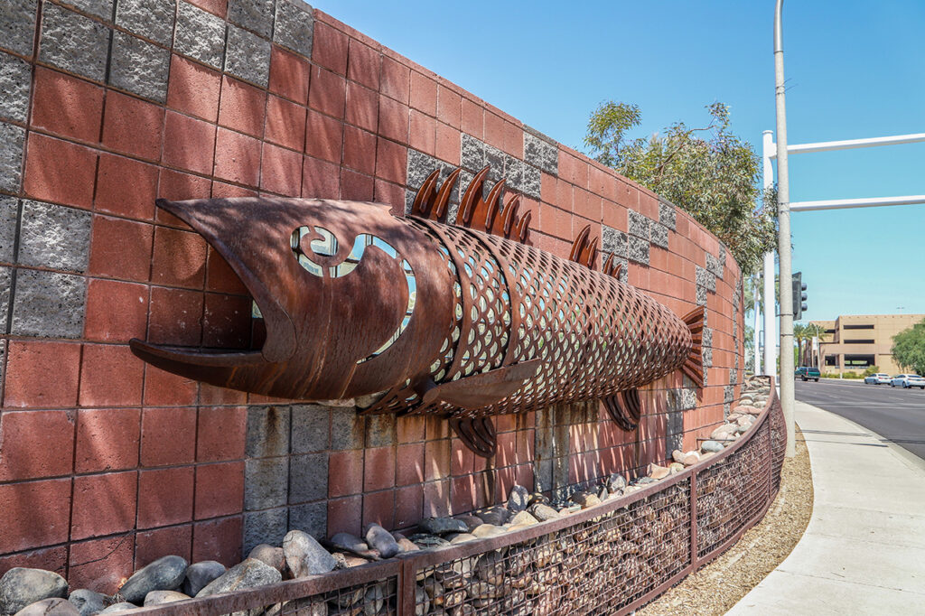
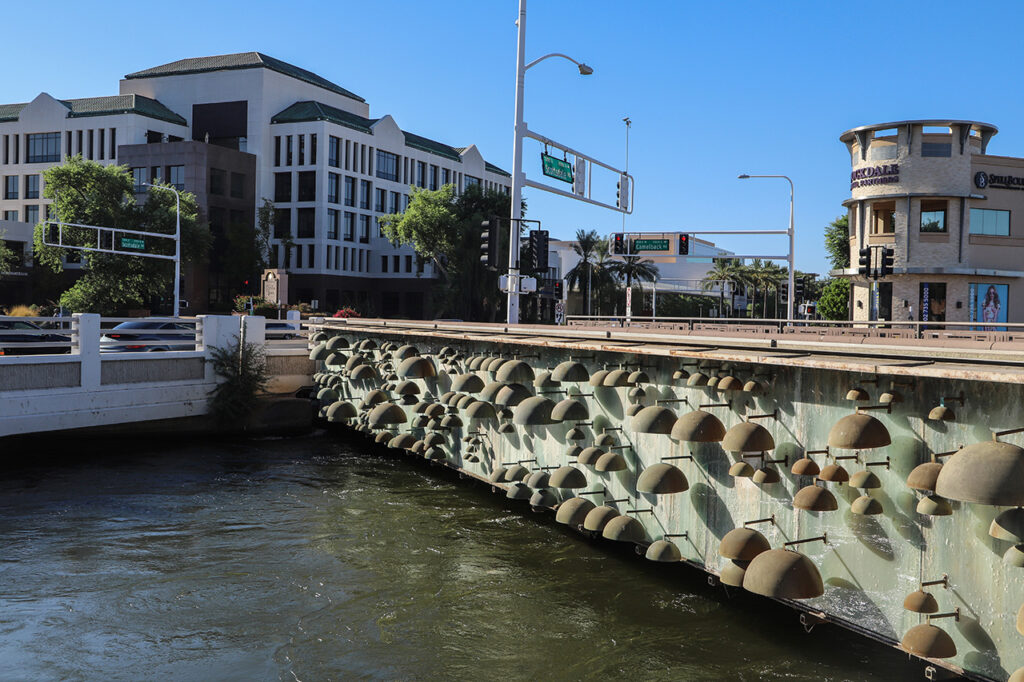
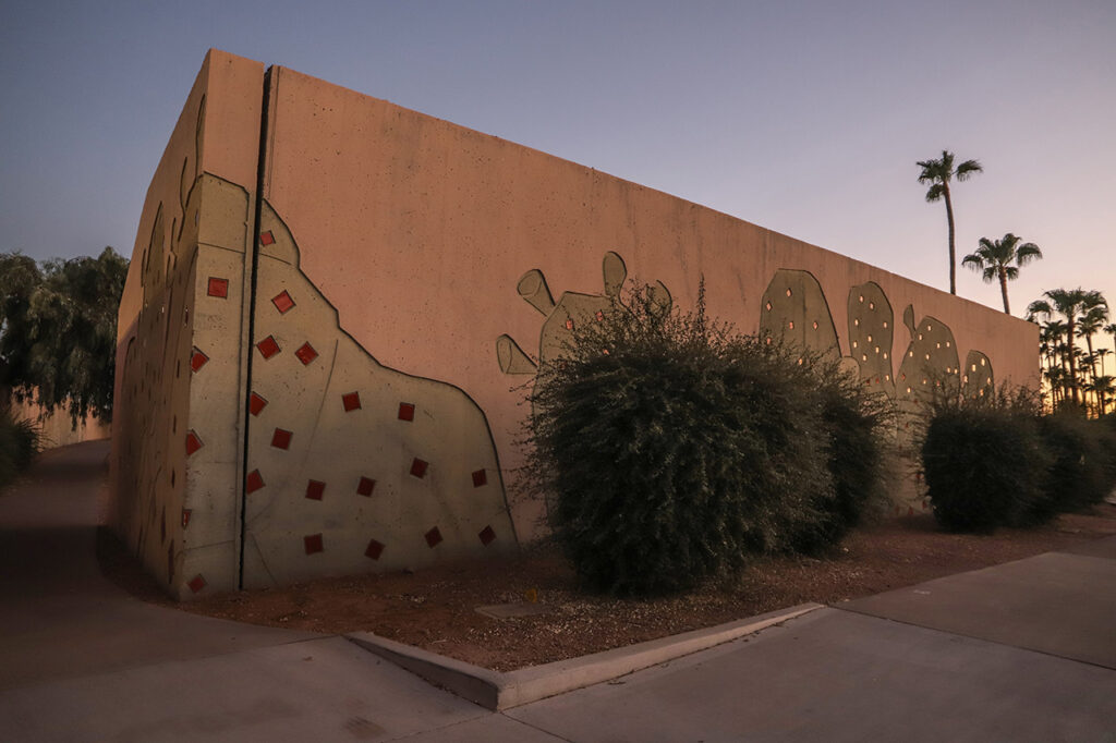
Tributary Wall by Kevin Berry — From your parking spot, take the crosswalk across Goldwater Boulevard at Via Soleri Drive to view Tributary Wall up close. This undulating sound abatement wall features seven steel fish sculptures with glass blocks behind them to allow light through the wall. At night, the fish are illuminated in a red glow. Learn more about the art and artist.
Walking directions to the next artwork: Return to the east side of Goldwater Boulevard and follow Via Soleri Drive to Marshall Way. At Marshall Way, turn south (right) and walk to the roundabout, which surrounds Passing the Legacy. (there are other artworks south of the bridge, but we’ll save them for the south Scottsdale route. Approximate destination address: Marshall Way and the north bank of the Arizona Canal.
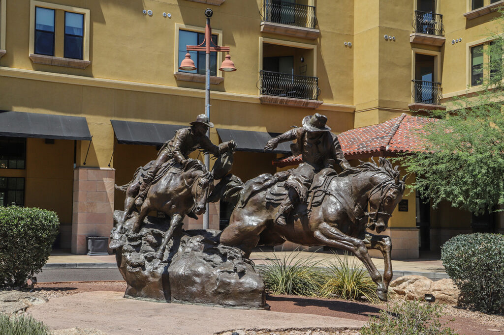
Passing the Legacy by Herb Mignery — This slightly-larger-than-life bronze depicts an historic Pony Express rider passing the mail to a modern rider, symbolizing the ongoing tradition of Arizona’s annual Hashknife Pony Express ride, which begins in Holbrook and ends at this sculpture. Learn more.
Walking directions: Return north on Marshall Way—continuing past Via Soleri Drive—to turn east (right) on Camelback Road. Walk east to the intersection with Scottsdale Road. Approximate destination address: southwest corner of Camelback Road and Scottsdale Road.
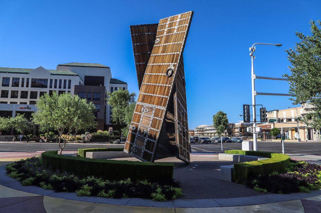
The Doors Donald Lipski and Sound Passage by Jim Green — There are two artworks in one here. Lipski’s The Doors is a sculpture of ipe (South American hardwood), mirror-polished stainless steel, LEDs, and thousands of steel rivets and strappings. To fully experience, you have to step inside and view the kaleidoscope effect and the aural textures of Green’s Sound Passage. Remember to safely distance from anyone outside of your household. Learn more.
Walking directions: Just across Scottsdale Road, to the east, is your next destination. Copper Falls is located along the Arizona Canal. Approximate destination address: southeast corner of Camelback Road and Scottsdale Road.
Copper Falls by Bob Adams — This artwork is not active during the hot summer months. When the water is running, it flows through a series of hemispheres arranged along a backdrop of frosted glass. With a patina of darkened bronze, the hemispheres come in a variety of sizes. Learn more.
Walking directions: Since the next artwork is located across both Scottsdale Road and Camelback Road, you can choose to cross either road first. Approximate destination address: northwest corner of Camelback Road and Scottsdale Road.
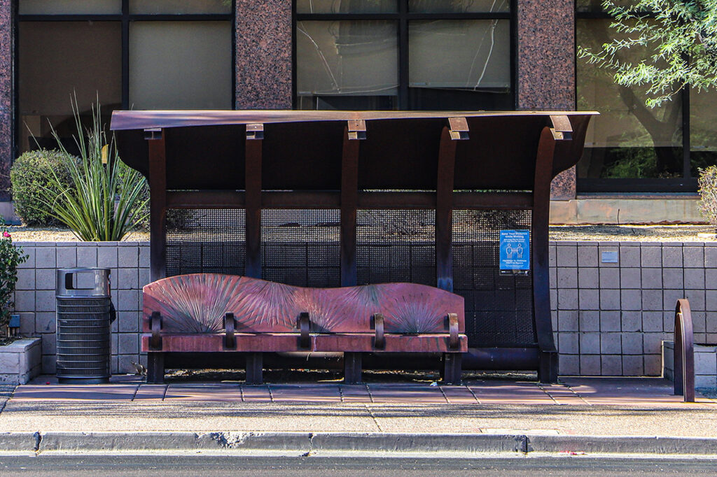
Wavelength by Kevin Berry — The same creative mind behind Tributary Wall (and two other artworks in the permanent collection) designed this series of elegant steel bus shelters with their distinctive wave-like shape. This one is located on the north side of Camelback Road in front of a commercial complex that includes E-Trade. Another is located on the same side of Camelback Road about 0.6 miles to the west, near a Wells Fargo Bank. A third is located on the east side of Scottsdale Road about 0.5 miles to the south, near Great Western Bank. Learn more.
Driving Directions: Return to your car to proceed to the next artwork. From your parking spot drive north on either Goldwater Boulevard or Marshall Way and turn east (right) onto Camelback Road. Follow Camelback Road east, across Hayden Road to the Club SAR fitness center on the south side of Camelback Road, tucked back in behind a facility used by the San Francisco Giants. Destination address: 8055 E. Camelback Road.
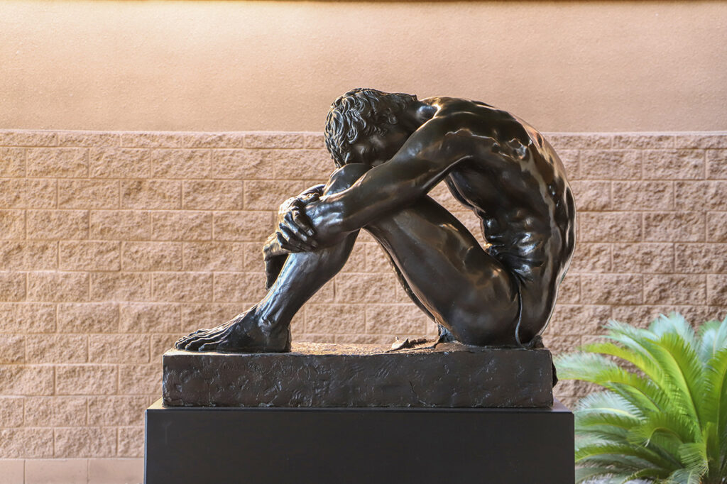
Michael’s Dream by Jasper D’Ambrosi — This bronze sculpture of a seated male figure depicts the late artist’s son Michael and was donated to the city by Michael’s mother/Jasper’s wife. The title refers to Michael’s dream of finding a cure for his daughter’s cystic fibrosis. Learn more.
Driving/Walking Directions: From Club SAR, turn west (left) on Camelback Road and then north (right) on Hayden Road. Follow Hayden Road to the northern end of Chaparral Park, almost to the intersection with McDonald Drive. Turn east (right) into the park near the entrance for the dog park and the xeriscape gardens. From the parking lot, follow the path along the southern perimeter of the dog park to the east as it curves south through part of the xeriscape gardens. Terraced Cascade is located along the path, with baseball fields to the west and south. Destination address for parking: 5878 N. Hayden Road.
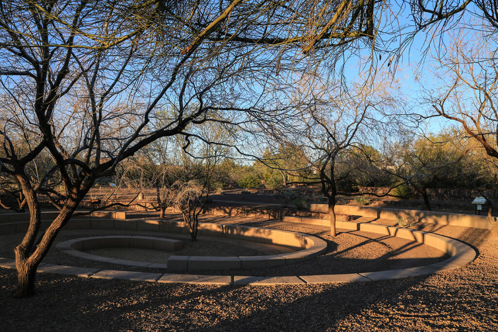
Terraced Cascade by Lorna Jordan — As much landscape design as it is public art, Terraced Cascade features curving hillside terraces that channel water runoff down a central ridge and into riblike planters. Learn more.
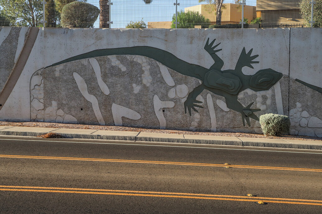
Driving directions: From Chapparal Park, continue north on Hayden Road and turn east (right) on McDonald Drive. As you cross Granite Reef Road, you will want make sure you’re in the left lane to turn into Agua Linda Park, which is located at the northwest corner of McDonald Drive and Pima Road. The parking area is on the east side of the park. If you don’t want to get out and see Lizard Acres up close, you can pull back out onto McDonald Drive, and look for the creatures along the low wall around the park while driving west. Destination address: 8732 E. McDonald Drive.
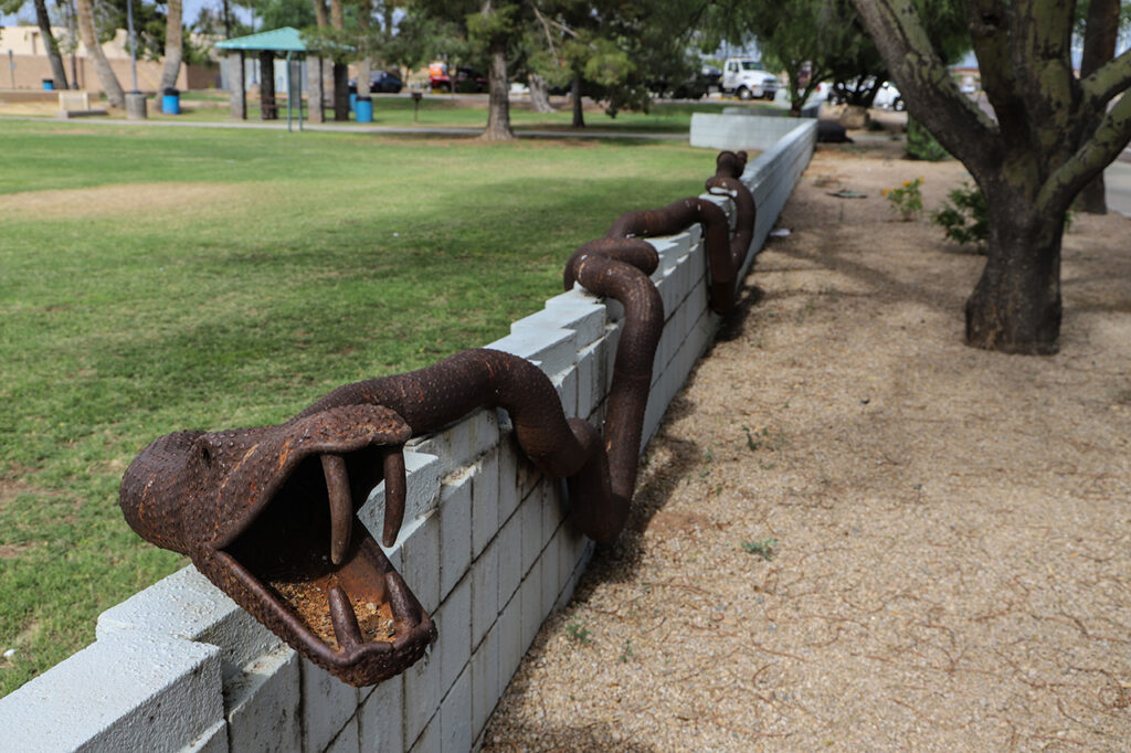
Lizard Acres by Joe Tyler — This delightful series of steel-and-rebar critters was inspired, in part, by the artist’s childhood haunt of the same name. Wander along the low wall on the south end of the park, fronting McDonald Drive, to look for horned toads, tortoises, snakes, and even some metallic prickly pears. Learn more.
Driving directions: From the Agua Linda parking lot, turn west (right), waving goodbye to Lizard Acres on your right as you continue west, across Hayden Road. Right after crossing the Arizona Canal—at what would be approximately 76th Street—you’ll see Industrial Pipe Wave rising up to the south (left) on the west side of the canal. Because it can be difficult to get a good look at the sculpture from the car, you can look for parking in a nearby neighborhood and walk back to it. Approximate destination address: southeast corner of McDonald Drive and Cattletrack Road.
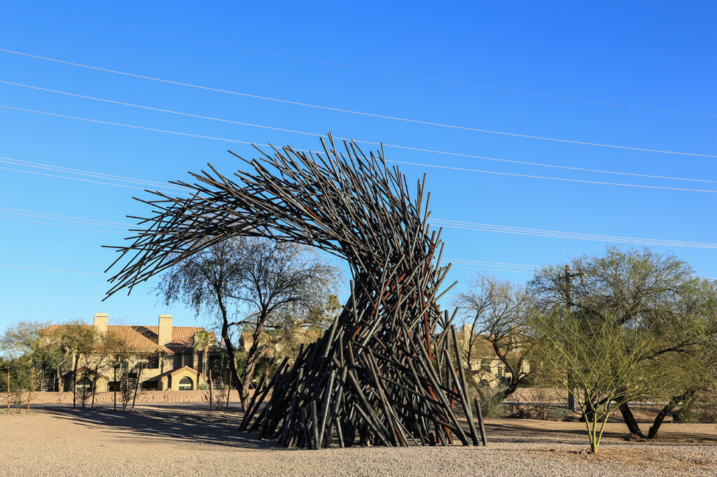
Industrial Pipe Wave by Christopher Fennell — One of the more striking pieces in the city’s public art collection, Industrial Pipe Wave is just what it sounds like: a massive wave made from salvaged industrial pipes. If you do find a place to park and enjoy the sculpture on foot, you’ll also find a moderately landscaped area with a few smaller sculptures that match the wave. Learn more.
Driving/walking directions: Whether you stop at Industrial Pipe Wave or not, it’s a good idea to turn around near the sculpture and return east along McDonald Drive before turning north (left) on Hayden Road. The reasoning will make sense at the next artwork. At Indian Bend Road, turn west (left) and then make sure you’re in the right lane, as close to the north side of the road as possible to ensure the best view of Water Mark on the right in Indian Bend Wash. To access by foot, you’ll likely have to find a parking spot near McCormick-Stillman Railroad Park, which is west of Water Mark on the south side of the road. If you park there, the closest crosswalk to access the north side of Indian Bend is the one at the intersection with Scottsdale Road. Approximate destination address: Indian Bend Road and Indian Bend Wash (between Rocking Road to the west and 78th Place to the east).
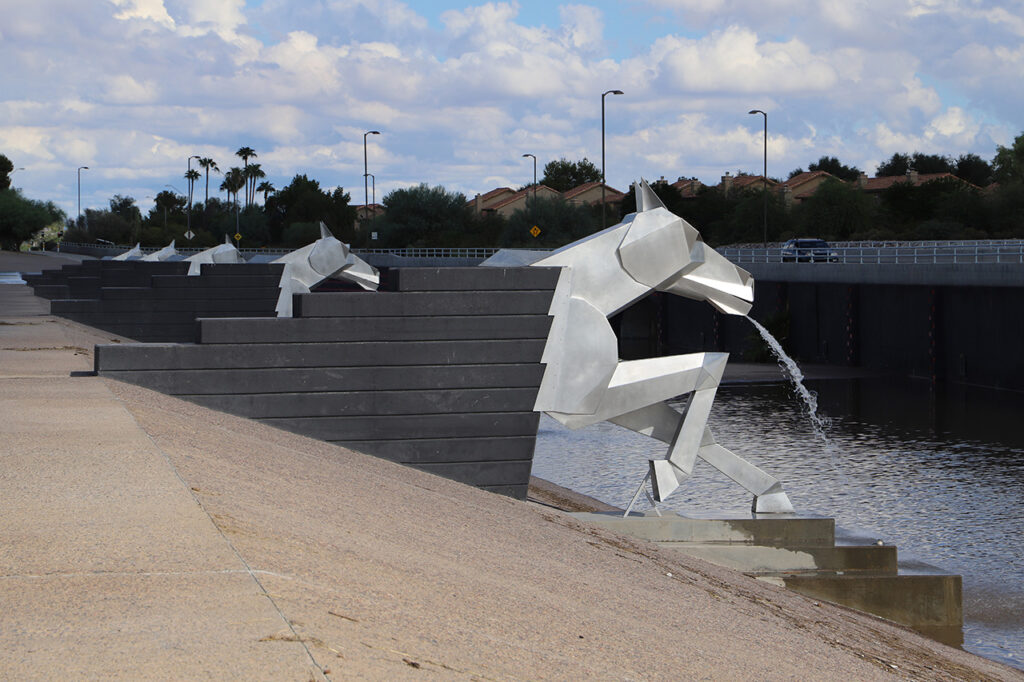
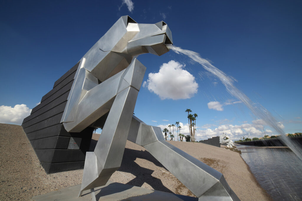
Water Mark by Laura Haddad and Tom Drugan — This series of five aluminum equine gargoyles is one of the most popular pieces in the city’s public art collection, especially during flooding events as water pours from the horses’ mouths. They are best viewed up close and on foot to appreciate their 14-foot height. But during a flooding event, make sure to stay out of the water. Learn more.
Driving directions: If you don’t stop at Water Mark, continue west along Indian Bend Road, then turn north (right) on Scottsdale Road and then east (right again) onto McCormick Parkway, which you will follow back to Hayden Road. Or, if you park at the Railroad Park, you can just turn east (right) out of the park and return to Hayden Road via Indian Bend Road. Either way, you’ll want to be turn north (left) onto Hayden Road and follow it northeast until you reach Via Linda. Turn east (right) onto Via Linda and follow the road as it winds along and crosses underneath the Loop 101 Pima Freeway. As you approach the underpass, you’ll see elements of The Path Most Traveled on both sides of the road. Approximate destination address: Via Linda underpass at the Loop 101 Pima Freeway.
The Path Most Traveled by Carolyn Braaksma — While the most prominent part of this massive artwork is located above you along the freeway, especially around the Shea Boulevard interchange, additional designs can be found at all the Loop 101 interchanges between this location at Via Linda and Scottsdale Road. But here along Via Linda, you can drive much slower than the freeway allows. With Braaksma’s artist-designed desert motifs adoring every one of the freeway’s interchanges or crossings for six miles, The Path Most Traveled is easily the largest work of public art in Scottsdale. Approximately 90 distinct images can be found along the walls, which can reach heights of 50 feet in some places. Seeing all of The Path Most Traveled would practically require its own driving tour to wind back and forth across the freeway. Learn more.
Driving directions: Continue east on Via Linda to 90th Street, where you will turn north (left). After crossing Mountain View Road, you will approach a roundabout. Turn east (right) at the roundabout to enter the parking lot for the Mustang Library. Destination address: 10101 N. 90th Street.
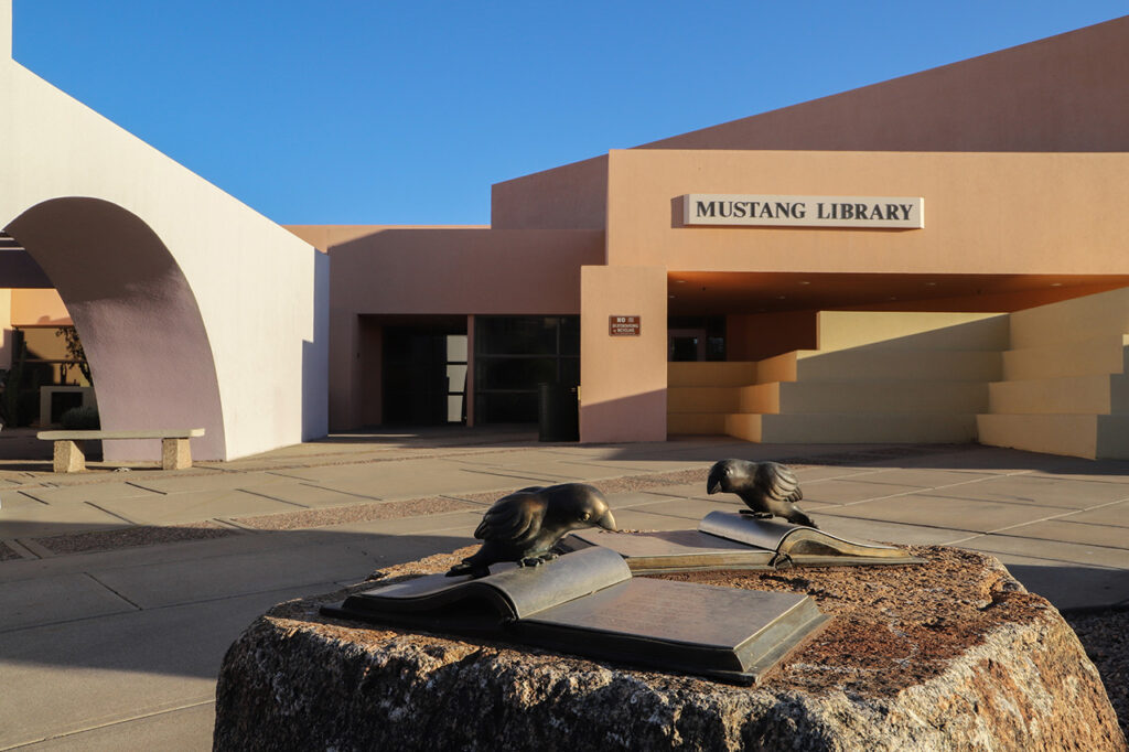
Birdie Umwelt by Mary Lucking — This installation features 20 sculptures of finches reading books, a series of sandblasted bird and feather images, and a sculpture of a birdhouse inspired by the library’s postmodern architecture. You’ll find the sculptures around the library and the nearby transit center on both the east and west sides of 90th Street. Learn more.
Driving directions: Leave the parking lot by turning north (right) on 90th Street. Turn east (right) on Shea Boulevard. As you cross 92nd Street, look for Sonoran Monsoon on the south (right) side of the road. If you want to stop to examine this bus stop in person, turn south (right) on 92nd Street and find parking nearby. Destination address: southeast corner of Shea Boulevard and 92nd Street.
Sonoran Monsoon by Joe Tyler — This is one of six bus stops along Shea that were designed by Tyler, who also created Lizard Acres. Two of the bus stops use the Sonoran Monsoon design—this one and one located on the north side of Shea, just west of the intersection with Via Linda. Learn more.
Driving/walking directions: Continue east along Shea Boulevard and turn south (right) at 96th Street. Then turn east (left) onto Via Linda and follow it northeast to approximately 105 th Street, where you will turn northwest (left) into the parking lot for the city’s Via Linda Senior Center. Locate An Abstraction by walking around behind (northeast side) the center. It cannot be seen from the parking lot, so make sure to distance if others are nearby. Destination address: 10440 E. Via Linda.
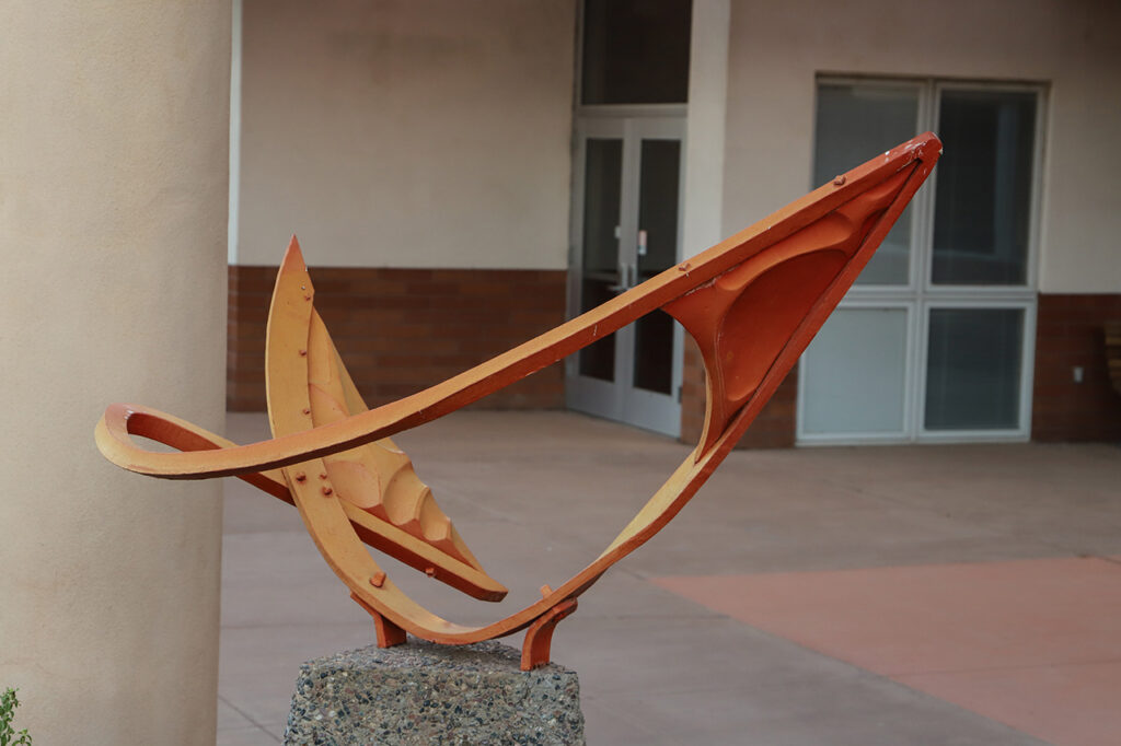
An Abstraction by Raymond Phillips Sanderson — This wrought-iron sculpture was fashioned by a traditional blacksmithing method—hand-forged on the anvil for the purpose of shaping and tapering. Learn more.
Driving directions: Turn northeast (left) from the parking lot onto Via Linda and continue to Shea Boulevard. Turn east (right) on Shea and begin to look for the various iterations of Desert Moods along the way. Four of these stylized bus stops are located between 124th Street and 136th Street. You’re most likely to find nearby parking for the last one, just past 136th Street, almost to Fountain Hills. Destination address: southeast corner of Shea Boulevard and 136th Street.
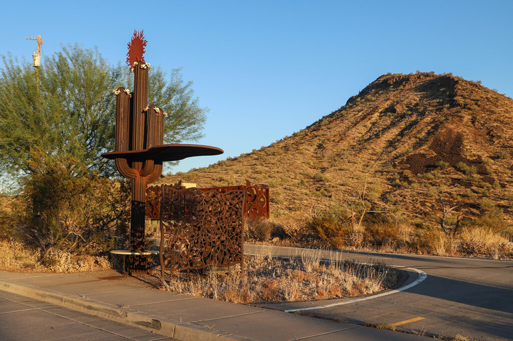
Desert Moods by Joe Tyler — Tyler’s Desert Moods design, which features a stylized saguaro cactus, can be found just east of 124th Street on the south side of Shea, west of 130th Street on the north side, west of 136th Street on the north side, and east of 136th Street on the south side. The last one boasts the prettiest location with conical hills in the background that are especially pretty during the magic hour before sunset. Learn more.
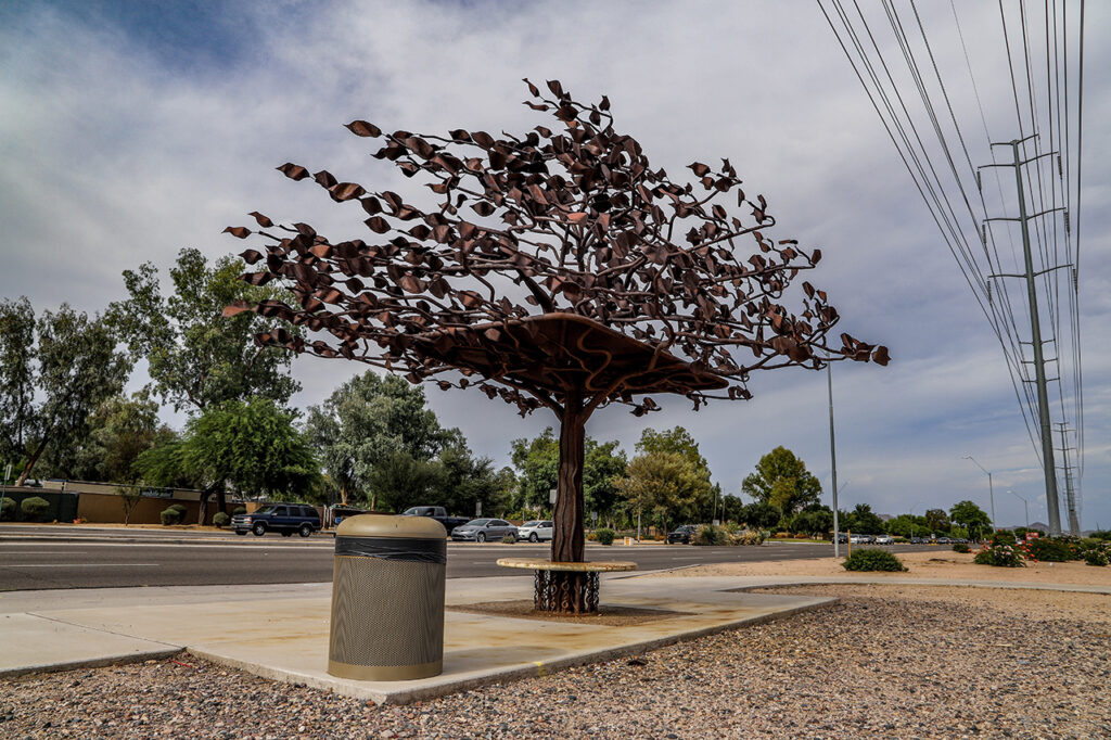
Driving directions: If you finish this route and are still craving a little more public art, you can always return to the Loop 101 corridor and look for more elements from Carolyn Braaksma’s The Path Most Traveled, like the artwork located at the Cactus Road interchange. You can view some of the art along the freeway by parking near the Mountain View Road overpass and walking over the Loop 101. And the artwork also faces the surrounding neighborhoods, which can be viewed along the west side of the freeway, both north and south of Mountain View Road, as pictured below. Of course, the most dramatic views can be had while driving the Loop 101 itself, especially north and south of the Shea Boulevard interchange.
* Alternate Beginning for Driving Only: If you don’t want to park and venture out on foot for the first part of this route, you can view all but Sound Passage and Copper Falls from your vehicle. For this route, drive south on Goldwater Water Boulevard and watch for Tributary Wall along the west (right) side of the road as you approach the Arizona Canal.
Turn west (right) at 5th Avenue and turn around in the parking lot along the canal. Return to Goldwater Boulevard and turn north (left) to drive back across the canal. At Via Soleri Drive, turn east (right), then turn south (right again) at Marshall Way, which will lead to a roundabout circling Passing the Legacy.
After circling, return north on Marshall Way—continuing past Via Soleri Drive—to turn east (right) on Camelback Road. Two artworks will be visible across the road from each other: one of the Wavelength bus shelters on the north (left) side of the road and The Doors on the south (right) side at the intersection with Scottsdale Road.
If you choose this alternate route, return to the main route above after the entry about Wavelength to continue the tour with Michael’s Dream, which does require walking to view (but only a short distance from a nearby parking lot).
Back to Immerse home.
CONNECTIONS: Spark | Amplify | Inspire